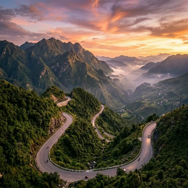
At 2,047 metres above sea level, Tram Ton Pass is the highest mountain road pass in Vietnam. Suspended between the ridges of the Hoang Lien Son range, it marks the border between Lao Cai and Lai Chau provinces and offers one of the most breathtaking panoramas in the entire country. For us, this pass is not just a crossing point — it is an unmissable stop on any journey to Sapa.
Where is Tram Ton Pass and how do you get there?
Tram Ton Pass is located about 15 km from central Sapa, on the national road leading to Lai Chau, at an altitude of 2,047 metres.
From Sapa, the road climbs steadily over roughly 15 kilometres before reaching the pass. This is the same route that passes the Silver Waterfall (Thac Bac), visible around 10 km from the town centre. By car or motorbike, the journey from Sapa takes between 20 and 40 minutes depending on traffic and weather conditions.
The pass is also known as O Quy Ho, the local name for the full 50-kilometre mountain road connecting Sapa to Lai Chau — one of the four great mythical passes of Northwest Vietnam. "Tram Ton" specifically refers to the highest point along this route, where an official sign marks the record altitude.
Ways to get there:
- By motorbike: the road is accessible year-round for experienced riders. We recommend setting off in the morning to catch the best light and avoid the afternoon mist that often rolls in.
- By car: with a local driver, this is the most comfortable option, letting you focus entirely on the scenery rather than the road.
- By taxi or tuk-tuk: several hotels offer day trips to the pass, often combined with a stop at the Silver Waterfall.
What makes Tram Ton Pass so spectacular?
Tram Ton Pass is a natural climatic divide: misty and cool on the Sapa side, it often gives way to sunshine and warmth just a few bends down the Lai Chau slope.
This weather contrast is due to the pass sitting directly on the crest of the Hoang Lien Son range. When Sapa's valley is buried in cloud, a few turns down the other side can sometimes reveal a clear sky and an open view over the Lai Chau lowlands.
At the summit itself, the view of the Fansipan massif on clear days is stunning. Vietnam's highest peak (3,143 m) rises dramatically to the south, while the steep flanks of the Hoang Lien Son drop sharply on either side of the road. Trekkers who climb Fansipan on foot cross one of these very slopes — a dizzying perspective when seen from above.
The atmosphere at the pass changes markedly with the seasons:
| Period | Conditions at the pass | Tip |
|---|---|---|
| September – November | Golden light, often clear skies | Best season for photography |
| December – February | Possible frost, thick mist, near-freezing temperatures | Bring warm layers; ride carefully |
| March – May | Lush vegetation, occasional morning showers | Beautiful colours, but variable visibility |
| June – August | Monsoon season, frequent fog, potentially slippery road | Extra caution on motorbike; check conditions first |
What is there to do and see around Tram Ton Pass?
The road to Tram Ton Pass combines several highlights: the Silver Waterfall, sweeping views over the Sapa valley, and trailheads for trekking towards Fansipan.
Silver Waterfall (Thac Bac)
About 12 km from Sapa, just before the pass, the Silver Waterfall drops 100 metres through an impressive forest setting. Accessed from a car park along the main road, it makes a natural stopping point on any excursion to the pass. Allow a modest entrance fee and around 20 minutes on foot to reach the base of the falls. We recommend visiting in the morning, when light filters through the trees and illuminates the cascade at its most photogenic.
Trekking to Fansipan from the pass
Tram Ton Pass is also the starting point for the Sin Chai trekking route, one of the three ascent paths to the Fansipan summit. This trail is considered wilder and less crowded than the classic route from Sapa town. It is suited to experienced hikers, requiring at least two days and a local guide. If you are considering this adventure, our article on the three trekking routes to Fansipan covers everything you need to plan your ascent.
The road to Lai Chau: the O Quy Ho descent
For travellers on motorbike or by car, the descent towards Lai Chau beyond the pass is one of the most spectacular drives in Vietnam. Over 50 kilometres, the road winds through ancient forests, sheer cliffs and villages of Dao and H'Mông minority communities. Few visitors travel the entire length, but those who do rarely forget it.
What are the practical tips for visiting Tram Ton Pass?
Always pack an extra layer: even in summer, Tram Ton Pass can be cool and windy, with temperatures typically 5 to 8°C lower than in Sapa town.
A few things to keep in mind before you head out:
- Temperature: in winter (December–January), the pass can freeze. Temperatures of 0 to 3°C are common. In summer, expect between 12 and 18°C at the summit.
- Road conditions: the road is fully paved, but rockslides are possible during rainy season. Drive carefully, especially on a motorbike.
- Parking: there is an informal parking area near the altitude marker, popular with local motorcycling groups.
- Food and drink: a few roadside vendors sell hot drinks and snacks at the pass, but do not count on a restaurant. Bring something to eat.
- Best time of day: morning for clarity; the pass frequently clouds over by mid-afternoon, particularly during the rainy season.
Want to experience this in Sapa?
Parfum d'Automne, our local expert agency, designs itineraries that go beyond the beaten path. We incorporate the hidden gems from our blog into your tailor-made journey.